Regionalized Expansion Scenarios for Subsidy-free Solar Parks – the Basis for Forward-Looking Grid Planning
The expansion of photovoltaics in Germany continues to gain momentum, both for rooftop and ground-mounted systems. This is a particularly relevant topic for grid operators, as they are increasingly receiving requests to connect very large new solar parks – some in the high double-digit to triple-digit megawatt range – which they have to consider in grid planning. To better assess trends and support efficient replacement and new construction measures, FfE has developed regionalized development scenarios for ground-mounted PV. Taking the German states of Bavaria, Saxony, and Schleswig-Holstein as examples, these scenarios were used to derive expansion probabilities for the different regions and identify upper expansion potentials for plants of different capacity classes up to 50 MW. Especially in the fast-growing area of subsidy-free solar parks in the power range above 20 MW (above 10 MW by 2021), such analyses are indispensable in order to align grid development with future large-scale projects.
With FfE’s regionalization model for ground-mounted PV plants, data from the regional plant inventory can be used to generate expansion scenarios with high spatial resolution. The focus of the most recent analysis for Schleswig-Holstein was on an area-specific consideration of the expansion until 2035. For this purpose, scenarios were developed that are based on the grid development plan (NEP) [1], a trend update of recent years, and the climate protection scenario fuEL of the Dynamis research project [2]. By considering both conservative and optimistic expansion corridors, a wide range of possible developments could be included.
For the modeling of the regional expansion in the scenarios, the methodology uses two decisive input variables: the plant inventory and the existing PV potential. Due to its high information content, the Market Master Data Register (MaStR) [3] forms the data basis for the plant inventory. In addition to processing this data by correcting incorrect information, more detailed information on the type of plant is supplemented from other data sets if this cannot be derived from the MaStR alone. To determine the potential for ground-mounted PV systems, a detailed analysis of geospatial data was conducted, taking into account all available land along transportation routes as well as agricultural land. Suppose the analysis is limited directly to subsidy-free solar parks with a corresponding footprint. In that case, narrow marginal strips around traffic routes, which are only suitable for smaller installations subsidized according to the EEG, can be excluded from the land area map with simple adjustments. In a second step, all known exclusion areas such as landscape protection areas, settlements, water bodies, and forests are subtracted from the remaining regions using geo-intersection.
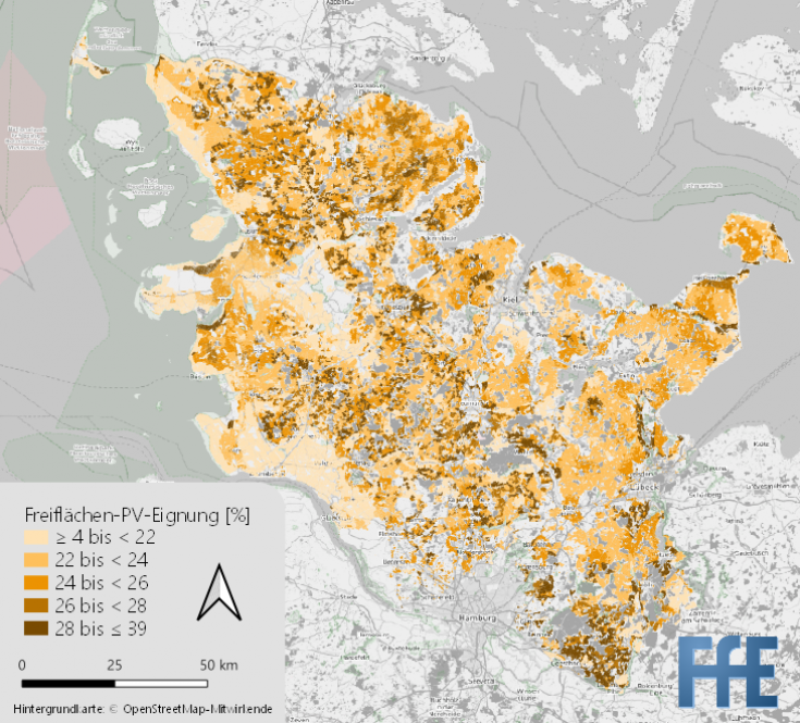
In order to bring the sheath numbers of installed capacity up to 2035 from the selected scenarios into the area, these must be distributed successively over the potential areas with the best suitability. The areas are evaluated using an area-wide grid with an edge length of 22 m, which combines up to 11 criteria per pixel in an average value. These include, for example, disadvantaged areas, soil fertility indicators, or proximity to existing electricity infrastructure such as substations to determine the probability of construction for each pixel of the grid. A sensitivity analysis can be used to examine the influences of each weighting factor and to check on a case-by-case basis which of the factors should be incorporated into the averaging to a greater or lesser extent. The regionalization of the power to be installed is then carried out using the areas with the best suitability. In the case of Schleswig-Holstein, the resulting evaluated potential for ground-mounted PV is shown in Figure 1.
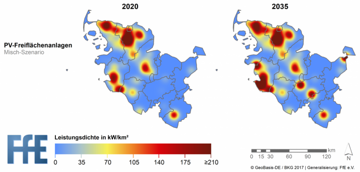
The consideration of different capacity classes from 10 to 50 MW also makes it necessary to differentiate according to the capacity-specific area requirements of the plants and to take into account contiguous areas when determining the probability of expansion. For this purpose, the potential areas are divided into corresponding sub-areas using spatial clustering. Depending on the power class, clusters of different sizes are then used within the potential areas, and the average rating of each cluster is recalculated. The power to be added is then done across the individual clusters within the potential areas, allowing for an analysis of how regional additions would occur with many small turbines or a few large turbines. The regionalization results for open space PV in Schleswig-Holstein are shown in Figure 2 using a mixed scenario as an example.
Comparing the data with existing plants and current inquiries shows that the status quo was well represented by the scenarios described here. In many areas, however, neighborhood effects, which are difficult to model, seem to play a non-negligible role and could also ensure a significant agglomeration of plants in the future. Also, the currently very high dynamics in many communities in the area of ground-mounted plants, as well as adjustments to the political framework of renewable development, cannot yet be clearly classified. Nevertheless, investment decisions will generally depend on whether a plant can be operated economically on the market even without financial support.
For the future, it will therefore be necessary to closely monitor the actual development in order to check the validity of the forecasts regularly. This makes it possible to make early adjustments in the forecasted output and react to them via the parameters of the scenario corridor. Together with the results of other regionalized studies on EEG plants, e-mobility, and heat pumps, the results can thus represent an essential tool for forward-looking grid planning.
Sources:
[1] Referat Netzentwicklung Stromübertragungsnetz: Genehmigung des Szenariorahmens 2021-2035. Bonn: Bundesnetzagentur für Elektrizität, Gas, Telekommunikation, Post und Eisenbahnen, 2020.
[2] Conrad, J.; Fattler, S.; Regett, A. et al.: Dynamis – Dynamische und intersektorale Maßnahmenbewertung zur kosteneffizienten Dekarbonisierung des Energiesystems. München: Forschungsstelle für Energiewirtschaft e.V., Forschungsgesellschaft für Energiewirtschaft mbH, Technische Universität München, 2019
[3] Marktstammdatenregister – Öffentliche Einheitenübersicht. In: https://www.marktstammdatenregister.de/MaStR/Einheit/Einheiten/OeffentlicheEinheitenuebersicht. (Abruf am 2019-03-07); Bonn: Bundesnetzagentur, 2019.
-
 19.02.2024Is charging electric vehicles with variable tariffs worthwhile? Attractiveness for electric vehicle drivers and business model potential for electricity providers and aggregators
 -
 20.10.2023From the use case to the living lab
 -
 18.10.2023Predictions in Energy Economics - Which Methods Are Suitable?